
Why Decades of Satellite Data Can't Predict Earth's Surprises
Even after decades of collecting massive amounts of data from satellites and sensors, major geological events still catch us off guard. Earth science analytics offers a solution.
Listening to a data-rich Earth
Despite vast data collection, Earth’s changes still surprise us. For decades, scientists launched satellites. They deployed ocean sensors. They drilled into ice and rock. We collected massive amounts of data about our planet. Even so, major geological events and sudden climate shifts still surprise us. Subtle environmental changes also catch us off guard. We had many pieces, but could not see the full picture. This gap drew me to earth science analytics. I questioned: were we poor listeners, or was Earth’s information too complex for old methods?
Earth science analytics is transforming how we understand our planet. This field is not just about collecting data. It teaches computers to interpret it. Computers find patterns no human could ever see. This field uses big data, AI, and machine learning. It applies them to the planet’s steady data streams. This work is happening worldwide. It affects local resource management and planetary climate models.
This technology is not just for academics. Governments use it for disaster preparation. Industries like mining and agriculture become more efficient. Environmental agencies rely on it for conservation. Before, we used manual observation and limited computer models. Now, data arrives in petabytes. This redefines what “analysis” truly means.
Earth’s data flood
In 2023, NASA’s Earth Observing System (EOS) generated 30 terabytes of new data daily. This data comes from a global network of satellites, ground sensors, and deep-ocean buoys. These instruments monitor atmospheric makeup, ocean currents, land use, and seismic activity. Much of this data used to stay siloed. Scientists analyzed it in fragments.
My research showed a clear problem: raw data is not insight. It’s just noise until processed. This is where earth science analytics steps in. It uses advanced algorithms, often with machine learning. These algorithms sift through massive datasets. They find anomalies, predict trends, and build models of Earth systems.
Take seismic data. The U.S. Geological Survey (USGS) has a network of seismographs. They record tiny ground movements. This generates gigabytes of data daily. Before, seismologists looked for major earthquakes. Modern analytics detects micro-seismic events. These often precede larger quakes. Dr. Emily Brodsky, a seismologist at the University of California, Santa Cruz, points this out. Her team uses machine learning. They find subtle patterns in seismic noise. People once dismissed these patterns as insignificant.
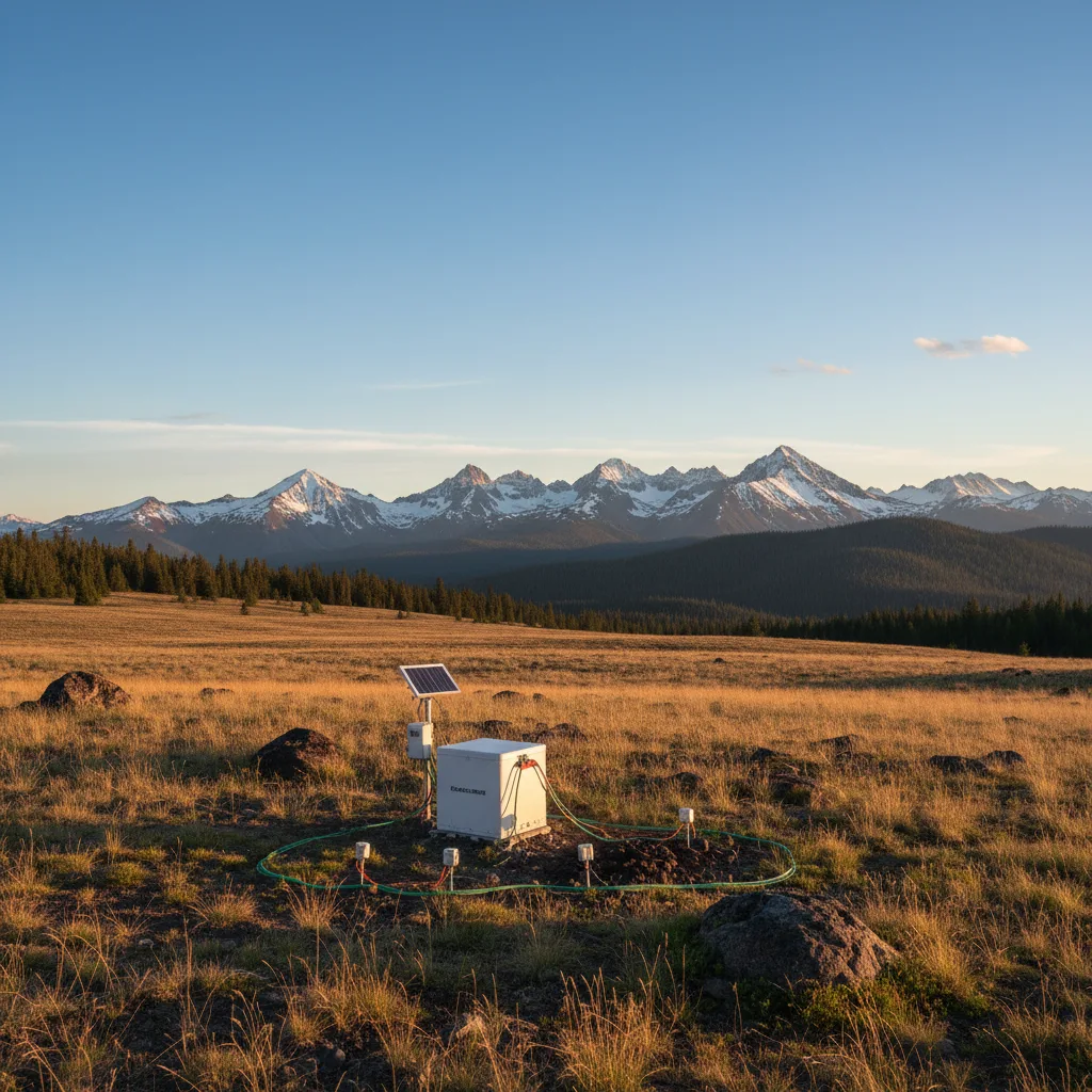
Modern seismographs, like those in the U.S. Geological Survey (USGS) network, continuously record ground movements, generating gigabytes of data daily. Earth science analytics uses this data to detect subtle micro-seismic events, which can precede larger earthquakes and were once dismissed as insignificant. (AI-generated illustration)
Satellite imagery is another example. Companies like Planet Labs image almost all Earth’s land daily. This creates petabytes of visual data. Researchers at the University of Maryland used Google Earth Engine. They processed decades of imagery. They mapped global forest change in great detail. Their 2021 report revealed localized deforestation hotspots. Broader surveys had missed these. This data helps conservation groups target intervention efforts.
Ocean data brings its own challenges. NOAA’s deep-sea buoys track temperature, salinity, and current speed. This helps predict El Niño events and track marine life. Machine learning models analyze these interactions. They now forecast ocean conditions weeks in advance. This improves shipping routes and fisheries management.
Surprising discoveries, real impact
In 2020, researchers at the Jet Propulsion Laboratory found something surprising. Using NASA’s GRACE-FO mission data, they saw glacier melt rates accelerate. GRACE-FO satellites measure tiny changes in Earth’s gravity. This shows shifts in mass, like melting ice. Analytics revealed Greenland’s ice sheet lost an average of 280 gigatons of ice per year between 2002 and 2021. This was faster than many climate models predicted. It forced a re-evaluation of sea-level rise projections.
My journey into this field revealed many “aha!” moments. Remote sensing analytics now predicts crop yields. For instance, a 2023 study by the European Space Agency (ESA) used Copernicus Sentinel satellite data. This data tracked vegetation health, soil moisture, and weather patterns. Their models predicted wheat yields in France with 90% accuracy, months before harvest. This helps farmers and governments make better decisions about food security and supply chains.
The impact on disaster preparedness is just as significant. In Japan, seismic analytics now combines real-time sensor data with historical records. This gives early warnings for tsunamis. The Japan Meteorological Agency combines this with ocean buoy data. They can issue warnings within minutes. This saves critical time. This capability was very difficult to imagine a generation ago.
However, it is not all certainty. Data models are only as good as their inputs. Professor Sarah Minson at the USGS often reminds us of model limits. She notes that biased historical data can skew predictions. For instance, seismic sensors often cluster near population centers. This can leave remote, geologically active areas under-represented. This adds uncertainty to predictions for those regions. We must be honest about what is well-established and what still needs more data and refinement.
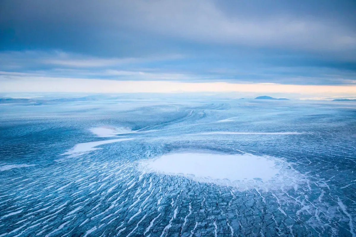
Greenland's ice sheet, a vast expanse of frozen water, is losing an average of 280 gigatons of ice per year, a rate faster than many climate models predicted and revealed by NASA's GRACE-FO mission data. (Source: sciencefocus.com)
Data integration is another challenge. Different agencies collect data in various formats. Harmonizing these different datasets takes huge computing power. This can slow down cross-disciplinary research. Still, the impact is clear. Earth science analytics does not just observe the planet. It actively helps us understand its interconnected systems.
The next frontier: open questions
Earth observation data will double by 2030. This will test our current analytical tools. The next step involves real-time analytics and Earth’s “digital twins.” Imagine a virtual, continuously updated replica of our planet. It simulates processes from deep-ocean currents to atmospheric chemistry. The European Centre for Medium-Range Weather Forecasts (ECMWF) already explores this. Their Destination Earth initiative builds high-resolution digital models. These models will predict climate change impacts in great detail.
One area still concerns me: ethics. Who owns this vast planetary dataset? How do we ensure fair access to these powerful tools? Dr. Karen Seto, a Yale geography professor, raises these points. She warns that powerful insights could create new data divides. Richer nations might gain significant advantages in resource management or disaster resilience.
Data interoperability is another challenge. We lack universal standards for sharing and combining datasets. This slows down collaborative efforts. The huge computing power needed is also a hurdle. Processing petabytes of data requires enormous energy. This raises questions about analytics’ own environmental footprint.
Despite these questions, earth science analytics changed my view. We are moving beyond simple observation. We are learning to understand our planet through its data. The future will blend AI with human expertise. This will reveal more about our active home. We are only just beginning to fully comprehend.
FAQ
What is Earth Science Analytics? Earth Science Analytics uses big data, AI, and machine learning on large Earth datasets. It helps scientists and industries understand Earth’s geological, atmospheric, and ocean processes. This leads to better predictions and decisions.
Where does the data for Earth Science Analytics come from? Data comes from many sources. These include Earth-orbiting satellites, ground sensors, seismic arrays, and ocean buoys. Historical climate records also contribute. This steady stream of information gives a full view of the planet.
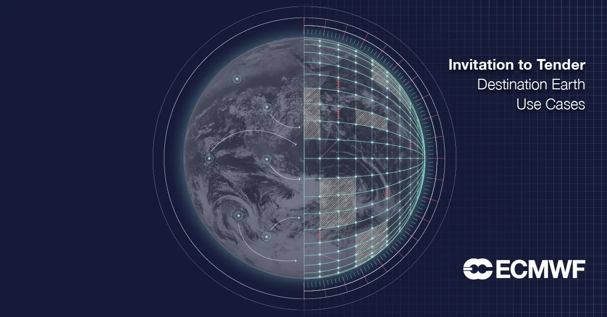
The European Centre for Medium-Range Weather Forecasts (ECMWF) is pioneering 'Destination Earth,' an initiative to create a high-resolution digital twin of our planet. This ambitious project aims to simulate complex processes from deep-ocean currents to atmospheric chemistry, providing unprecedented detail for climate change prediction. (Source: stories.ecmwf.int)
How does Earth Science Analytics help with natural disasters? It analyzes real-time sensor data. This predicts earthquakes, tsunamis, and landslides. This allows for earlier warnings and better preparedness. It also models extreme weather impacts, helping recovery.
What are the biggest challenges facing Earth Science Analytics? Challenges include the large data volume and making different systems share data. The large computing power needed is also a hurdle. Ethical questions about data ownership and fair access to these tools also exist.
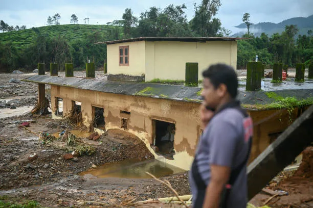
Earth Science Analytics plays a crucial role in predicting natural disasters like landslides, which involve the rapid movement of rock, debris, or earth down a slope. Early warnings derived from real-time sensor data can help communities prepare and mitigate the devastating impacts of such events. (Source: gettyimages.com)
You might also like:
👉 Super El Niño 2026 Predictions: Global Impact & What to Expect